In early 2014, I decided to acquire a small HD wearable camera (Sony HDR-AS30V) capable of being mounted on a bicycle in rough environments and having high resolution capability as well as imbedded GPS. I already had a Garmin Edge 510 bike computer with GPS and heart rate and cadence sensors. Thoroughly geeked out, I guess you might say.
The thought was to use the camera GPS data and video for fun, mostly, but also in case of a traffic altercation; documenting what happened and when, regardless of who is wrong, is important. I also want to create series of short training videos for emerging bicyclists to understand the etiquette of the trail and road to keep them safe.
What I found after a couple of days of using this technology was that I had a few surprises coming! Not all were good. The version of the camera firmware is V2.00 (downloaded and installed on 2/14/14). The "supplied" software (PlayMemories Home) is at V3.0.31.01170, installed from the Sony website on 2/12/14. The version of DashWare used is V1.4.4. This software is not free, but is available for a 30 day trial. I got the trial for a few days, then paid for the license. It is not cheap, but for what it does and has the capability of doing, it is very reasonably priced!
Let me start by saying that Sony Product Support, if they really want to support products, should be transparent. It is nearly impossible to find anything other than a telephone number (not toll-free) with which one can get support. There is a community board (very difficult to negotiate and find subjects) on which I might get an answer. I'm not too hopeful. I looked for a way that I could post a question to the Customer Relations Team, but I can't find a way. (Note: After several weeks of posting AS-30V questions on the Forum, it appears that I am not the only one whose unit has poor accuracy. Sony has not provided a sufficient answer to the deficiency. Sigh!)
HDR-AS30V
Kudos: The ability to connect to a smart phone to see if you are lined up is great! I can't speak to the power drain on the tiny battery, but one can always turn off the WiFi when aligned. The Contour camera I used a while back has two LED beams you can use for alignment and pointing. This is better.
It would be nice to have an easier WiFi password than the random data assigned to the device. One would hope that one only needs to enter it once into the phone, but...
Kudos: The camera is small, lightweight, and, in the supplied case, pretty insensitive to the environment (i.e.rain). Caveat: The camera will get quite warm in the case, especially if it is exposed to the sun. I'm working on a solution for this, because summer is hot!!
Deficiency: No elevation data in the recorded GPS data file. What? Nope, it's not there. The data file format is NMEA and the field definitions are quite specific. Here is a typical set of data for a recorded point. I have added, in RED, where the elevation should be located. Just before that, in BOLD is the number of satellites used in the measurement. Note that zero (0) is shown, but we do have some data.
$GPGGA,184519.000,3941.1195,N,10511.1769,W,1,0,,ElevationHere,M,,M,,*6E
$GPRMC,184519.000,A,3941.1195,N,10511.1769,W,11.25,,160214,,,A*5B
Searches for this issue show no one else seems to have this problem. This is hard to believe. It should be noted that, right out of the box with V1.00 firmware, the same issue exists.
Deficiency: Movie and GPS data are likely "offset" in time. I took about 14 separate movies during a ride and found that the time-tag of the start of the file and duration did not match the extent of the start time and data duration in the GPS log file.
Stated another way, there can be a significant delay when you start recording a movie when the unit is powered down until the GPS data is locked and "catches up". This time appears to vary (in my sampling, from 0 up to 18 seconds), but the longer the camera is off means the longer it takes to obtain a lock, and the more of the GPS data is not recorded.
To its credit, the time of the last GPS record matches within a second or two of the time expected at the end of the video. This small discrepancy can be easily explained by the start time/duration of the video only being accurate to the nearest second.
To compensate, I either call out the seconds time hacks when I start recording, or actually record my Garmin on the video, then match the data up that way. There are still "tim sync" issues, but these are due to the way data are sampled and stored, not a particular deficiency in the unit itself.
Deficiency: Accuracy of GPS Positional Data (not elevation, obviously)
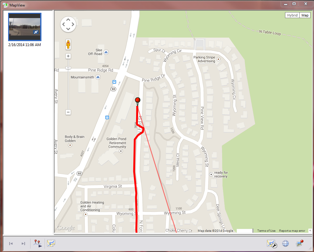
I used the GPS Support Tool to preload the Sony unit with GPS ephemeris data (makes acquisition of satellites easier) the night before, so I would have expected the accuracy of the position would be decent. It is not. First, ignore the line heading down the the right. This is an artifact of the software (deficiency?) that you cannot "ignore" track data from all the other movies taken on this day. The things to note are the start location (GPS data did not start when I left the intersection), and the "wiggle" in the track. Looking at the movie, there's no wiggling whatsoever. compare that with a portion of the GPS track from the Garmin. The Garmin shows how I went up on one side of the road, then down on the other side of the road.
Sony HDR-AS30V
|
Garmin 510
|
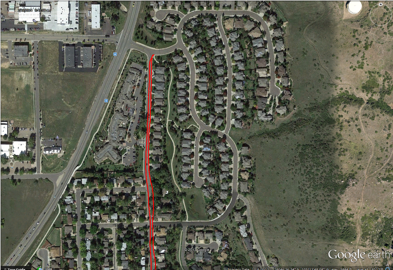
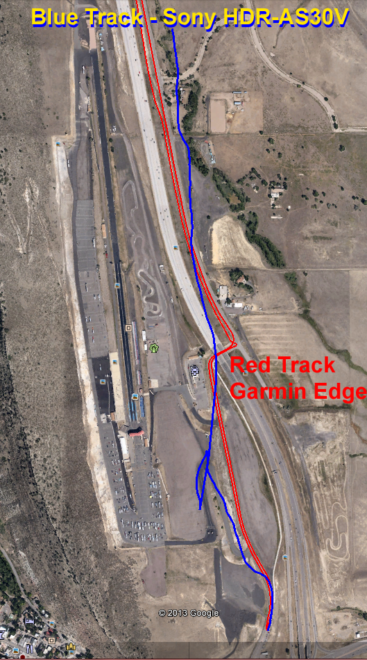
I analyzed a section of trail at the start of my ride that day, and calculated the difference in position between the Sony (blue) and the Garmin (red). The initial position delta was nearly zero, but the max error was over 0.6 km (1800 feet!). That's not good! You can see that the Garmin traced my path along the road and bike trail (as I headed north), but the Sony put me way off track, to the west and to the east of my actual path. The Garmin trace (in RED) also has the return trip on it (west side of the road, heading south)!
PlayMemories Software
The software is adequate. Even so, there are a couple of deficiencies that show up (note that these are obvious after only 4 days of playing with it).
First, attempting to use MapView (where the GPS track is overlaid on a Google Map) showed an error screen. Why a user should have to have Microsoft Office 2000 Premium is beyond me, but apparently something isn't installed properly. Again, searching the Internet yielded no solution to this problem. I happen to have this product and was able to install the CD and have the problem "go away".
In MapView, there is a "play" button (see image above, bottom of the image, third icon from the left), but it doesn't appear to work. Clicking on it does nothing.
The GPS log files extracted from the device and "linked" to a particular movie file are very easily "unlinked", and cannot be re linked without downloading the data again. While I can accept that the linkage might be made only once, it would seem that if one used the software to move a file to a different location that the linkage would move. OH, wait! You can't move the files using the software. So, once you've put the data into the system, you're stuck with where you've put it. If you manually move data, then you're hosed forever.
To their defense, you can pick where you want the files to be stored/linked when you download them.
Combining video files is easy, but the limit is 4 GB. Period. If you have created a bunch of high resolution files, you are out of luck trying to combine these into a single video stream.
For quick display of velocity data and date/time, the software is exceptionally easy to use (at least on Windows7 PC's). Just select Tools:Edit Media Files:Create Multi-View on a single video to have a "dashboard" inserted into the image. You can save this to a separate file, which is cool. The accuracy of the Sony recorder is, however, abysmal.
DashWare 1.4.4
Combining your data logging with the video in this tool is very easy. There are some things I've found so far if accurate synchronization is important to you.
Combining the Sony track log or an external data source can be a little tricky to get accurate. The track log files are importable to DashWare, so no problem there. But the delta in time between when the video starts and when the GPS data is available (regardless of source) is observable only when either (a) viewing the video to see where the data picks up, or (b) open the data files and looking for time tags. Even then, there are delays internal to the video/display data that require explanation. In the file created by DashWare, the date was wrong. During the import, the date is in the second log entry, not the first, so the software just assumes today's date. Not good, but since the absolute date/time is never displayed to the casual user, it's OK.
DashWare has a robust interpolation/integration set of functions that process the incoming data. What this means is that the displayed data may be "delayed" from the raw data recorded in the GPS file, depending on the data source selected for the gauge displayed.
Which is a long explanation that says, it is more difficult to synchronize the data and video that a simple time hack analysis might suggest. I have found that an additional delay inserted into the GPS data for both the Sony GPS log and the Garmin Edge 510 data of 4 seconds more accurately synchronizes the video to the GPS product.